TOP 10 MOST BEAUTIFUL CANYON IN THE WORLD
TOP 10 MOST BEAUTIFUL CANNON IN THE WORLD
10.KINGS CANYON, CALIFORNIA

Kings Canyon National Park is a national park in the southern Sierra Nevada, in Fresno and Tulare Counties, California in the United States. Originally established in 1890 as General Grant National Park, it was greatly expanded and renamed to Kings Canyon National Park on March 4, 1940. Its namesake, Kings Canyon, is a rugged glacier-carved valley more than a mile (1,600 m) deep; the park also includes multiple 14,000-foot (4,300 m) peaks, high mountain meadows, swift-flowing rivers, and some of the world's largest stands of giant sequoia trees. Kings Canyon is north of and contiguous with Sequoia National Park, and the two are jointly administered by the National Park Service as the Sequoia and Kings Canyon National Parks.

Kings Canyon National Park is a national park in the southern Sierra Nevada, in Fresno and Tulare Counties, California in the United States. Originally established in 1890 as General Grant National Park, it was greatly expanded and renamed to Kings Canyon National Park on March 4, 1940. Its namesake, Kings Canyon, is a rugged glacier-carved valley more than a mile (1,600 m) deep; the park also includes multiple 14,000-foot (4,300 m) peaks, high mountain meadows, swift-flowing rivers, and some of the world's largest stands of giant sequoia trees. Kings Canyon is north of and contiguous with Sequoia National Park, and the two are jointly administered by the National Park Service as the Sequoia and Kings Canyon National Parks.
9.ANTELOPE CANYON, ARIZONA

Antelope Canyon is a slot canyon in the American Southwest. It is on Navajo land east of Page, Arizona. Antelope Canyon includes two separate, scenic slot canyon sections, referred to individually as "Upper Antelope Canyon" or "The Crack"; and "Lower Antelope Canyon" or "The Corkscrew".
8.WAVE CANYON, ARIZONA

The Wave is a sandstone rock formation located in Arizona, United States near its northern border with Utah. The formation is situated on the slopes of the Coyote Buttes in the Paria Canyon-Vermilion Cliffs Wilderness of the Colorado Plateau. The area is administered by the Bureau of Land Management (BLM) at the Grand Staircase-Escalante National Monument visitor center in Kanab, Utah.
The formation is well–known among hikers and photographers for its colorful, undulating forms and the difficult hike required to reach it. Due to the fragile nature of the formation and the large number of people wishing to visit it, a daily lottery system is used to dispense only ten next–day permits in person at the Kanab visitor center. Additionally, ten online permits for each date are available four months in advance of a planned trip. A map and information about the hike are supplied to those who have obtained permits.
7.BRYCE CANYON, UTAH, USA

Bryce Canyon National Park /braɪs/ is a United States national park located in southwestern Utah. The major feature of the park is Bryce Canyon, which despite its name, is not a canyon, but a collection of giant natural amphitheaters along the eastern side of the Paunsaugunt Plateau. Bryce is distinctive due to geological structures called hoodoos, formed by frost weathering and stream erosion of the river and lake bed sedimentary rocks. The red, orange, and white colors of the rocks provide spectacular views for park visitors. Bryce sits at a much higher elevation than nearby Zion National Park. The rim at Bryce varies from 8,000 to 9,000 feet (2,400 to 2,700 m).
6.WAIMEA CANYON, USA
Waimea Canyon, also known as the Grand Canyon of the Pacific, is a large canyon, approximately ten miles (16 km) long and up to 3,000 feet (900 m) deep, located on the western side of Kauaʻi in the Hawaiian Islands of the United States. Waimea is Hawaiian for "reddish water", a reference to the erosion of the canyon's red soil. The canyon was formed by a deep incision of the Waimea River arising from the extreme rainfall on the island's central peak, Mount Waiʻaleʻale, among the wettest places on earth.
5.VERDON GORGE, FRANCE

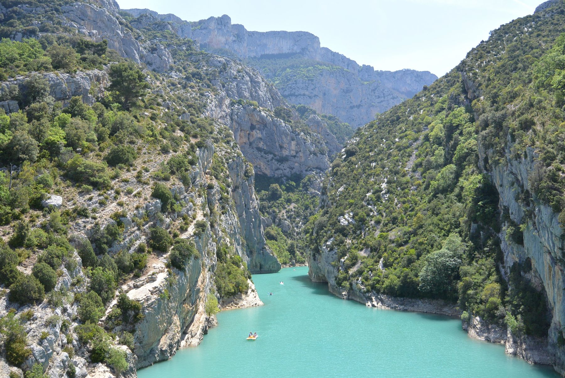
The Verdon Gorge (in French: Gorges du Verdon or Grand canyon du Verdon), in south-eastern France (Alpes-de-Haute-Provence), is a river canyon that is often considered to be one of Europe's most beautiful. It is about 25 kilometres long and up to 700 meters deep. It was formed by the Verdon River, which is named for its startling turquoise-green colour, one of the location's distinguishing characteristics. The most impressive part lies between the towns of Castellane and Moustiers-Sainte-Marie, where the river has cut a ravine to a depth of 700 metres through the limestone mass. At the end of the canyon, the Verdon River flows into the artificial lake of Sainte-Croix-du-Verdon
Wulingyuan ([ù.lǐŋ.ɥɛ̌n]; Chinese: 武陵源) is a scenic and historical site in south-central China's Hunan Province. It was inscribed as a UNESCO World Heritage Site in 1992. It is noted for more than 3,000 quartzite sandstone pillars and peaks across most of the site, many over 200 metres (660 ft) in height, along with many ravines and gorges with attractive streams, pools, lakes, rivers and waterfalls. It features 40 caves, many with large calcite deposits, and two natural bridges, Xianrenqiao (Bridge of the Immortals) and Tianqiashengkong (Bridge Across the Sky).
3.PIVA CANYON, MONTENE

The canyon is cut between the mountains of Bioč, Volujak, Maglić and Pivska planina, its 33 km long, deep up to 1.200 m and river generates immense power used for the power station of Mratinje (342 MW) which dammed the canyon in 1975. The dam is 220 m high, one of the highest in Europe and creates Lake Piva, third largest in Serbia and Montenegro (12,5 km², altitude 675 m, 188 m deep), which flooded the old location of the monastery of Piva from the 16th century, so the monastery was moved to the new one. The Vrbnica river flows from the left into the lake.
2.FISH RIVER CANYON, AFRICA

The Fish River Canyon (Afrikaans: Visrivier Canyon or Visrivier Afgronde, German: Fischfluss Canyon), is located in the south of Namibia. It is the largest canyon in Africa, as well as the second most visited tourist attraction in Namibia. It features a gigantic ravine, in total about 100 miles (160 km) long, up to 27 km wide and in places almost 550 meters deep.
The Fish River is the longest interior river in Namibia. It cuts deep into the plateau which is today dry, stony and sparsely covered with hardy drought-resistant plants. The river flows intermittently, usually flooding in late summer; the rest of the year it becomes a chain of long narrow pools. At the lower end of the Fish River Canyon, the hot springs resort of Ai-Ais is situated.
1.GRAND CANYON, USA

The Grand Canyon (Hopi: Ongtupqa; Yavapai: Wi:kaʼi:la, Navajo: Tsékooh Hatsoh, Spanish: Gran Cañón) is a steep-sided canyon carved by the Colorado River in Arizona, United States. The Grand Canyon is 277 miles (446 km) long, up to 18 miles (29 km) wide and attains a depth of over a mile (6,093 feet or 1,857 meters).
The canyon and adjacent rim are contained within Grand Canyon National Park, the Kaibab National Forest, Grand Canyon-Parashant National Monument, the Hualapai Indian Reservation, the Havasupai Indian Reservation and the Navajo Nation. President Theodore Roosevelt was a major proponent of preservation of the Grand Canyon area, and visited it on numerous occasions to hunt and enjoy the scenery.
View More Blogs :


Comments
Post a Comment